

Seattle weather: Wet and windy night ahead for western Washington
Seattle Weather: High wind warning through Tuesday morning
FOX 13 is Seattle and Western Washington’s source for breaking news, weather, traffic and sports.
SEATTLE - We are tracking strong wind gusts and heavy rain across western Washington overnight into Tuesday morning. Some areas could wake up to power outages and downed trees.
What To Know:
- Pockets of moderate-to-heavy rain could slow the early commute.
- Traveling will become quite challenging over the mountains – particularly at Stevens and White Passes. There’s a small chance that snow will be accumulating at Snoqualmie Pass, too.
- There’s an elevated risk of landslides around Western Washington and avalanches in the backcountry of the mountains.
- Showers will gradually taper Tuesday afternoon – except for where a convergence zone is ongoing.
- A Winter Storm Warning is posted for most of the Cascades above 4,000 feet in elevation. Upwards of one to two feet of snow could fall, depending on the location.
- Between five and twelve inches of snow (or more) could fall along Snoqualmie Pass: totals there will depend on how quickly temperatures cool to the freezing mark tonight (if they cool that low at all).
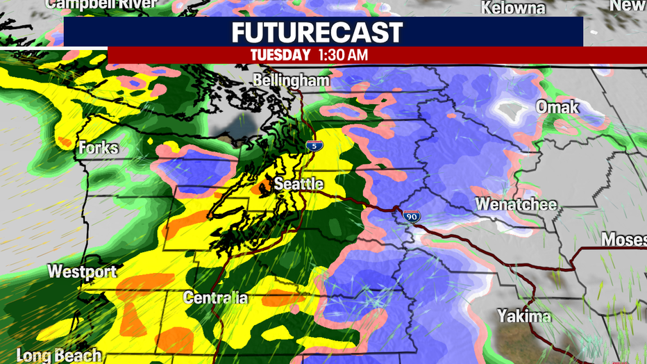
A strong low moves onshore, increasing the widespread rainfall. It may be heavy at times.
What's next:
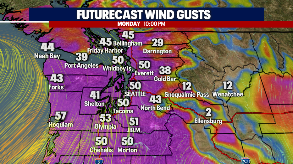
- Winds become rather widespread by 7 p.m., but gusts won’t peak for many in Puget Sound until between 10 p.m. today and 4 a.m. Tuesday. Winds will ease much more substantially by noon on Tuesday.
- Some communities could wake up to power outages and downed trees. Greater impacts are expected in the South Sound and along the coast.
- Should winds get as strong as we expect, there could be roads closed due to downed trees in addition to dark intersections with the power off.
A deep low pressure area will move onshore overnight, increasing winds from the south.
- Gusts could reach upwards of 55-65 mph along the Washington coast. That’s where high surf could create super dangerous conditions along the water as well.
- Gusts could range between 50-60 mph for the South Sound, Kitsap Peninsula and the Southwest Interior.
- For those covered in a Wind Advisory, there could be gusts to 45-50 mph.

Strong winds will increase from Monday evening to Tuesday morning in the greater Seattle area. (FOX 13 Seattle)
Looking Ahead:
After a stormy start to Tuesday, a quieter weekend ahead with more sun breaks and highs near 60. Another slight chance of showers by the weekend.
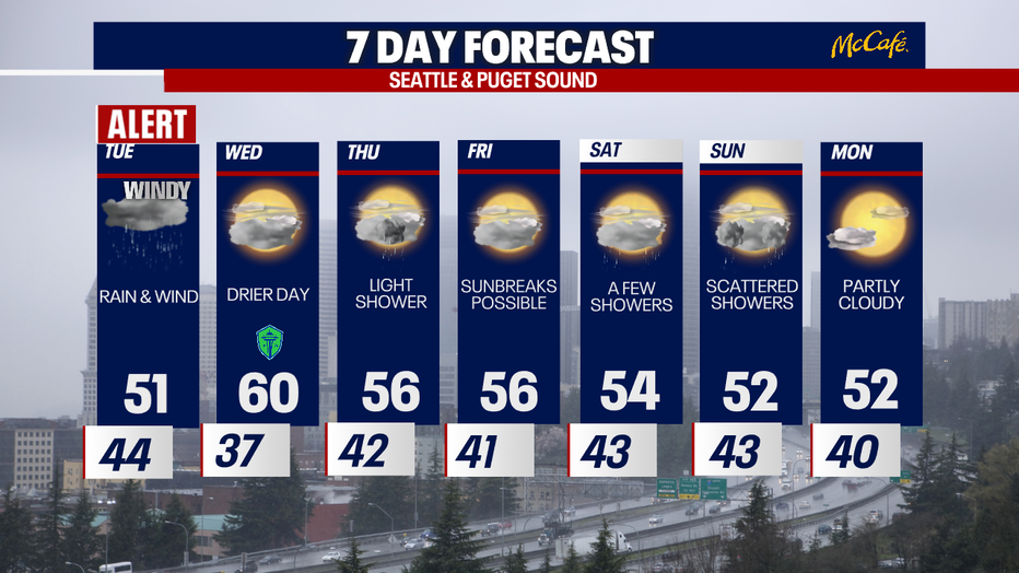
After a stormy start to Tuesday, a quieter weekend ahead with more sunbreaks and highs near 60.


Windy, wet storm causing power outages in Seattle, western WA
Thousands are without power and outages are expected to rise Monday night as high winds roll in, meeting vulnerable trees in topsoil soaked by a weekend of rain.
The Source: Information in this story is from FOX 13 Seattle Meteorologist Ilona McCauley and the National Weather Service.
MORE TOP STORIES FROM FOX 13 SEATTLE
Puyallup man killed, family now sending ashes back to Japan: ‘That’s his final trip’
4 arrested following car jacking, crash, chase in Spanaway, WA
‘You steal for a living’: Everett antique store confronts accused serial shoplifters
2 bills aimed at improving community safety in WA advance
Pirate plunders boat motors from Gig Harbor, WA marina
To get the best local news, weather and sports in Seattle for free, sign up for the daily FOX Seattle Newsletter.
Download the free FOX LOCAL app for mobile in the Apple App Store or Google Play Store for live Seattle news, top stories, weather updates and more local and national coverage, plus 24/7 streaming coverage from across the nation.