

Seattle winter weather: Lowland snow continues overnight into Thursday morning
Seattle weather: Icy, snowy Thursday morning commute
FOX 13 Seattle Meteorologist Ilona McCauley is tracking a treacherous Thursday morning commute, with another round of lowland snow expected into Wednesday evening.
A low pressure system parked offshore will continue to spin showers into the greater Puget Sound area Wednesday night into Thursday morning.
Here’s a breakdown of what is next:
WEDNESDAY EVENING & THURSDAY MORNING
Bands of lowland snow started falling earlier in the afternoon and will continue into the overnight hours as temperatures fall and rounds of showers continue to push into the Puget Sound area. The showery nature of this precipitation makes it tough to pinpoint exactly where the heaviest snow will fall, but this round of snow has a potential of impacting more areas.
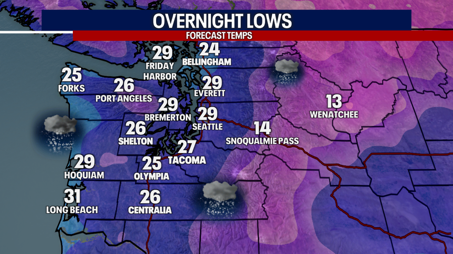
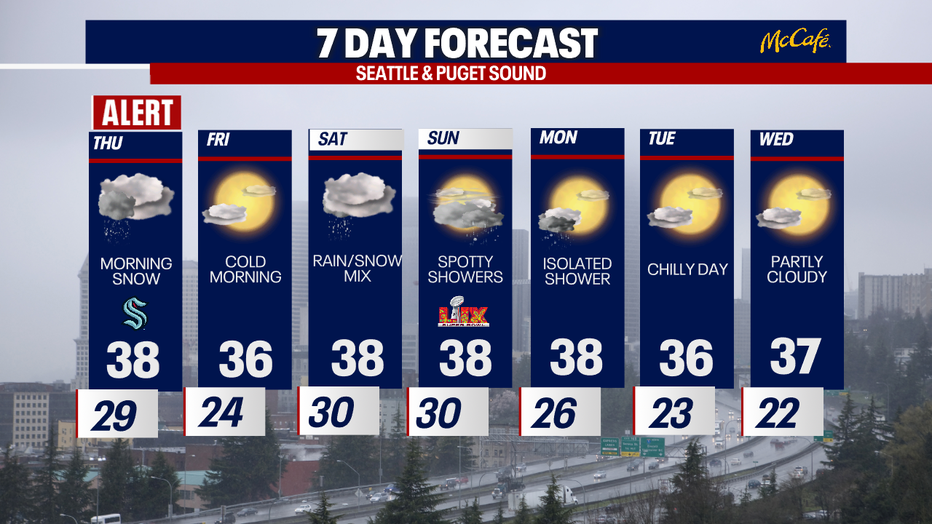
Cold night ahead with lows in the 20s areawide. (FOX 13 Seattle)
What's next:
A trace to 3 inches is possible in most lowland locations from Arlington to Chehalis. There will be spots that get close to nothing and other areas could achieve more than three inches. The biggest factors will be how fast it gets cold and how long precipitation lasts tonight. The Washington Coast will see fewer showers than inland locations later tonight. The best chance for snow will remain around the Puget Sound area.
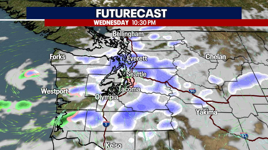
A lingering area of low pressure will rotate in snow showers overnight. (FOX13 Seattle)
Travel on area roadways will once again be very difficult with icy conditions by morning. Just like the last few days, use caution and take your time!
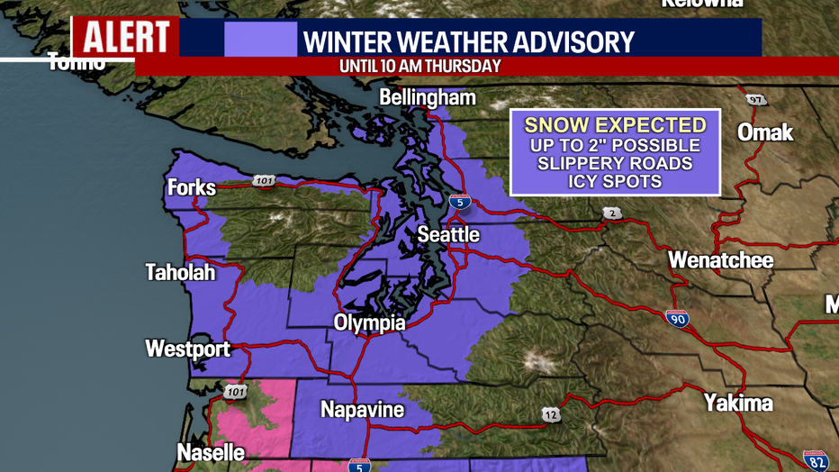
Snow showers will lead to difficult travel on area roadways Thursday morning. (FOX 13 Seattle)
THE REST OF THURSDAY
We should dry out by the second half of the morning commute, with sunshine on tap for the second half of the day. Temperatures will warm again to the mid 30s, which should help melt any snow or ice on the main roads by midday.
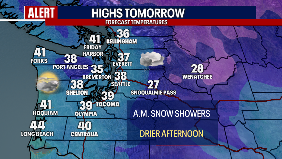
A cool day with highs only topping out in the 30s. (FOX 13 Seattle)
FRIDAY & THIS WEEKEND
Friday looks dry and partly cloudy, but still cool. There is a chance of some light showers this weekend. I can’t completely rule out overnight light snow this weekend, but it won’t amount to much.
A cool week ahead with a brief dry break Friday afternoon. Another slight chance for showers Saturday morning. (Fox13 Seattle)


School closures: Track closings, delays in western WA for Thursday, Feb. 6
Schools districts in western Washington continue to report delays and closures due to wintry conditions.
MORE TOP HEADLINES FROM FOX 13 Seattle
School closures: Track closings, delays in western WA for Thursday, Feb. 6
Seattle principal arrested for DUI and domestic violence after car flips
Japan Airlines plane impales tail of Delta plane at Sea-Tac Airport
More than 1K rally outside Olympia Capitol in '50 states, 50 protests' demonstration
Washington Senate passes changes to parental rights in education
1 dead, 1 saved as US Coast Guard makes dramatic nighttime rescue in WA
To get the best local news, weather and sports in Seattle for free, sign up for the daily Fox Seattle Newsletter.
Download the free FOX LOCAL app for mobile in the Apple App Store or Google Play Store for live Seattle news, top stories, weather updates and more local and national coverage, plus 24/7 streaming coverage from across the nation.