

Live updates as bomb cyclone brings high winds, rain to West Coast
North Sound reeling from bomb cyclone
Tens of thousands of customers are still without power in Snohomish County after getting hit hard by the bomb cyclone windstorm Tuesday night.
SEATTLE - A major storm was sweeping across the northwest U.S., battering the region with strong winds and rain. It caused widespread power outages and downed trees that killed at least one person.
Falling trees struck homes and littered roadways across northwest Washington, while nearly 600,000 were without power Wednesday morning.
Fire officials in Lynnwood, Washington, say a woman died when a large tree fell on a homeless encampment.
Keep reading for live updates on the bomb cyclone.
WATCH: Live coverage from FOX 13 News
9:00 p.m.
Many school districts are canceling classes or starting late on Thursday due to the lingering effects of the windstorm.
Check school closures here:


School closures: Track closings, delays in western Washington for Thursday, November 21
Some western Washington school districts will be closed or delayed on Thursday, Nov. 21 due to the lingering effects of the "bomb cyclone" storm.
7:00 p.m.
Eastside Fire and Rescue responded to a house fire in Issaquah, believed to have been caused by a generator. Fire crews say this is the fourth generator-related fire they responded to in Issaquah on Wednesday.
Issaquah home burns down, generator possibly sparked fire
Fire crews responded to a house fire that was possibly caused by a generator on Wednesday, their fourth generator-related fire of the day in Issaquah.
There were no reported injuries. The city of Issaaquah is also opening its senior center for those without power.
4:00 p.m.
Mirrormont, Carnation south end under boil water advisory
The south end of Carnation is currently under a boil water advisory. Door hangers were left on affected houses.
The Washington Water Service is also advising customers in the Mirrormont water system to use boiled tap water or bottled water until further notice.
The windstorm caused a power outage and damage to the water system. Mirrormont is located south of Issaquah and north of Hobart in King County.
12:50 p.m.
Eastside Fire & Rescue reports several generator fires
Eastside Fire & Rescue has dispatched crews to at least three fires caused by generators in the wake of Tuesday night's bomb cyclone.
Officials warn that you must keep your generator outside and fuel it outside, do not store generator fuel in your house, and before refueling your generator, turn it off and let it cool down.
9:00 am
Bellevue Fire Department responds to carbon monoxide calls
The Bellevue Fire Department is starting to respond to carbon monoxide calls. As many turned to portable generators to keep their homes running during the bomb cyclone storm Tuesday, it's important to know how to stay safe while using a portable generator during a power outage.
8:00 a.m.
At least two deaths have been reported in western Washington as a result of the bomb cyclone storm.
Tree falls onto Bellevue home, killing woman
A tree fell onto a house killing a woman in the Bellevue area. (Bellevue Fire Department)
At 7 p.m., crews with the Bellevue Fire Department responded to the Bridle Trails neighborhood after a person called about a tree that fell onto their home.
Fire officials said the caller reported that their spouse had been killed.
Tree falls onto woman in encampment, killing her
Firefighters with South County Fire responded to a report of a tree that fell after 7 p.m. near Alderwood Mall Parkway. According to officials, the woman who died was in her 50s.
Tree falls onto King County Metro bus
Powerful winds from Tuesday night's bomb cyclone caused a tree to fall onto a King County Metro bus in the Seattle’s Wedgwood neighborhood overnight.
FOX 13 Reporter Shawn Chitnis responded to the scene to gather more information.
Chitnis reports that the power is out in the surrounding area, and he has spotted multiple large trees down en route to the Metro bus incident site.
Several hours after the incident was reported, crews are still working to cut the tree and clear the debris to release the bus.
7:00 a.m. Wednesday
Washington power outages
At its peak, PowerOutage reported 606,606 customers without power across the state, with at least 330,000 without power in King County.
At 6:15 a.m. Wednesday:
- 561,706 customers were without power in Washington state.
- Seattle City Light reports 66,869 customers without power.
- Puget Sound Energy reports 414,359 customers without power.
- Snohomish County PUD reports 73,753 customers without power.
- Lewis County PUD reports 1,619 customers without power.
Western WA school closures and delays
Dozens of school districts were closed or delayed because of power outages and storm damage. Check the updated list.
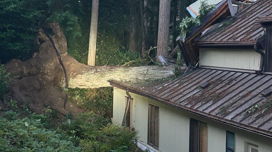
Massive trees down from Lake Stevens to Mill Creek
Multiple trees have fallen onto roads, homes and businesses across Washington state amid Tuesday's "bomb cyclone" storm.
10:30 p.m.
Several western Washington school districts are announcing late starts or closures on Wednesday due to effects from the strong windstorm.


School closures: Track closings, delays in western Washington for Wednesday, November 20
Some western Washington school districts will be closed or delayed on Wednesday, Nov. 20 because of the damaging "bomb cyclone" storm.
9:45 p.m.
Downed wires reported on Beacon Avenue South in Seattle's Rainier View neighborhood.
Redmond Police also report multiple roads blocked due to downed trees and wires.
There are currently 493,517 customers without power across the state, according to PowerOutage.


120K WA residents without power from bomb cyclone. Here's what to know
Crews throughout western Washington are monitoring outages as high winds move into the region.
9:10 p.m.
South County Fire reported a woman in her 50s died after a large tree fell on a homeless encampment near Alderwood Mall Parkway around 7 p.m.
There were no other reported injuries.
Power outages across the state have reportedly surged, with over 450,000 customers without power.
9 p.m.
Sound Transit reports significant delays on the 1 Line, along with power outages at some 2 Line stations.
Eastbound I-90 is closed six miles west of Cle Elum due to a jack-knifed semi blocking the roadway.
The 1st Ave S Bridge will also remain up for the remainder of Tuesday night.
Downed trees continue to block multiple local roads, including Maltby Road in Bothell, SR 169/Renton-Maple Valley Road in Renton, and State Route 18 between I-90 and Issaquah-Hobart Road.
8:00 p.m.
Puget Sound Energy's website is currently down. At last check, over 50,000 customers were without power, with at least 438 active outages.
Snohomish County PUD is also experiencing issues with its outage map. Customers can report outages by calling 425-783-1001.
More trees continue to fall in Issaquah, as Eastside Fire and Rescue reported multiple in the past few hours. The public is asked not to call 911 if a tree falls down in the road, but to call road services instead.
The Bellevue Fire Department is also reporting numerous trees falling onto homes across the city. Residents are advised to stay away from windows and get to the lowest floor.
7:27 p.m.
Outages across Washington have dropped down to 41,000.
The final two sailings of the Vashon route water taxi have been canceled due to weather concerns.
6:51 p.m.
More than 100,000 customers are without power across Washington, according to PowerOutage's outage map. 106,119 households are down, including 29,508 in King County, 13,031 in Pierce County, 12,087 in Clallam County.

6:27 p.m.
Outages across Washington have reached 92,159 customers.
Meanwhile, a system-wide outage has hit Anderson Island, leaving residents in the dark possibly overnight. Tanner Electric Cooperative's island crew was moved to North Bend to rectify an outage there.
6:19 p.m.
Wind speeds over 50 mph have been reported by people in Enumclaw.
North Bend lost power right in the middle of Lauren Donovan's live report:
Bomb cyclone: North Bend already seeing power outages
High winds are already being reported across western Washington, with more power outages expected throughout the night.
5:30 p.m.
Power outages have been reported across western Washington, with roughly 46,398 customers without power. In Clallam County, 11,055 are without power, and 6,443 without power in Snohomish County.
Additionally, Eastside Fire & Rescue have reported at least two trees have come down.
"The time to stay indoors and avoid travel is here. [We have] started responding to storm related calls our service area," wrote Eastside fire officials. "The winds are expected to continue through tomorrow morning, please be safe. This tree fall is in Issaquah — thankfully, no injuries."
Crews are also reporting trees down in Lake Stevens.
1:00 p.m.
FOX 13 Meteorologist Abby Acone's forecast
Western Washington was slammed by an atmospheric river last week, which is again a factor tonight, but there is a marked difference between an atmospheric river and a bomb cyclone.
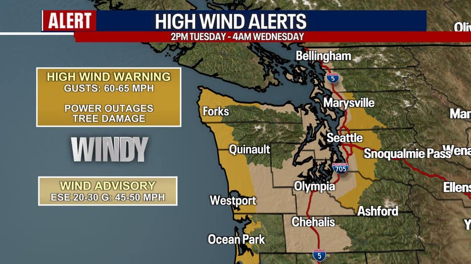
A High Wind Warning is in effect from 2:00 p.m. Tuesday to 4:00 a.m. Wednesday for the coast and eastern Snohomish, King and Pierce counties. East to southeast, gusts could reach 55–65 mph with sustained winds of 25–40 mph. The strongest winds will be along the coast and near the Cascade foothills.
Winds will peak between 5–10 p.m. tonight, with the potential to cause power outages. Gusts will gradually ease throughout Wednesday morning. It may take time for the power to come back on, so keep that in mind.

Powerful winds are forecast east and west of Seattle on Tuesday night. (FOX 13 Seattle)
A Wind Advisory is in effect from 2 p.m. today to 4 a.m. Wednesday elsewhere in Puget Sound where moderately strong winds are likely. Southeast winds in places like Everett, Bellingham, Olympia and Seattle could reach 15-30 mph with gusts to 50 mph.
A rare Blizzard Warning is in effect from 4 p.m. today to 10 a.m. Wednesday for the Washington Cascades at and above 2,500 feet in elevation. There could be snow accumulations between four and 12 inches with locally higher amounts over the highest peaks.
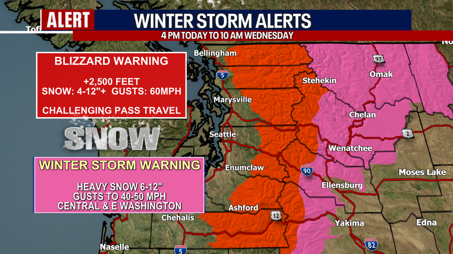
A rare Blizzard Warning is posted for the Washington Cascades Tuesday night. (FOX 13 Seattle)
This is only the sixth Blizzard Warning issued for the Washington Cascades by the National Weather Service office in Seattle in the last 40 years. In order to warrant an official Blizzard Warning, conditions need to meet the following criteria:
- Winds in excess of 35 mph
- Visibility dropping to less than a quarter of a mile out
- Lasting for at least three hours
Unfortunately, we're predicting all of that and more. We strongly encourage you to avoid traveling over the passes tonight.
Tonight, there will also be moderate to heavy rain racing through Western Washington. High surf conditions are forecast along the coast. Keep it here with the FOX 13 weather team. We'll be watching the latest for you closely.
10:46 a.m.
WSDOT warns ferry passengers to prepare for possible service disruptions starting Tuesday afternoon through Wednesday morning. WSDOT is keeping a close eye on monitoring sailing conditions for the Anacortes-San Juan Island and the Port Townsend-Coupeville routes. WSDOT has already seen one ferry cancelation due to weather conditions.
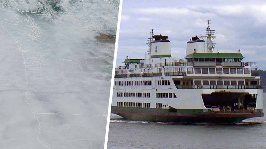
Even if ferry sailings remain on schedule, WSDOT is urging riders to anticipate bumpy journeys through the region and suggests that Dramamine may be helpful in preventing motion sickness.
READ MORE: How the bomb cyclone storm will impact WA ferry sailings
10:40 a.m.
The Washington State Department of Transportation (WSDOT) releases a hand-drawn map showing how specific weather conditions caused by the bomb cyclone will impact travel across the state.
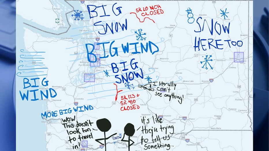
"HEY. SO. We've got strong winds and a blizzard warning in the mountain passes today, PLUS the potential for coastal storms and flooding. If you're looking for a sign to delay your trip: THIS IS YOUR SIGN. In flashing neon letters! Expect blizzard-li
WSDOT also provided a few links to get travelers prepared for the storm ahead:
10:00 a.m. Tuesday
FOX 13 Chief Meteorologist Brian MacMillan says gusts of 40-50 mph are possible in the Puget Sound lowlands, with gusts of 55-65 mph on the western slopes of the Cascade foothills. The wind will slowly back off after midnight.
Strong winds will trigger a High Wind Warning and Wind Advisory for Western Washington Tuesday afternoon through early Wednesday morning. (FOX 13 Seattle)
A blizzard warning has been issued for the majority of the Cascades in Washington, including Mount Rainier National Park, starting Tuesday afternoon, with up to a foot of snow and wind gusts up to 60 mph, according to the weather service in Seattle. Travel across passes could be difficult if not impossible.

Strong winds and heavy mountain snow is expected for the Cascades above 2500 feet by Tuesday evening. (FOX 13 Seattle)
Washington State Patrol Trooper John Dattilo, a patrol spokesperson based in Tacoma, posted on social media Monday afternoon that people should be prepared for "some bad weather" on Tuesday night. "Stay off the roads if you can!"
In southwestern Oregon near the coast, 4 to 7 inches of rain is predicted — with as much as 10 inches possible in some areas — through late Thursday night and early Friday morning.
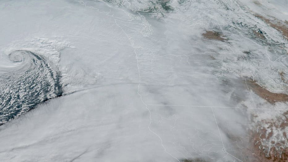
A view of a bomb cyclone off the U.S. Pacific Northwest coast as seen by NOAA's GOES-West - satellite. (NOAA)
A high wind warning has been issued for the north and central Oregon coast beginning at 4 p.m. Tuesday with south winds from 25 mph to 40 mph, with gusts to 60 mph expected, according to the weather service in Portland. Gusts up to 70 mph are possible on beaches and headlands.
Widespread power outages are expected with winds capable of bringing down trees and power lines, the weather service said. Travel is also expected to be difficult.
The Source: Information in this story is from FOX 13 Seattle's own reporting, The Associated Press and the National Weather Service.
MORE NEWS FROM FOX SEATTLE
Docs: WA man pistol-whips infant son, kidnaps family in high-speed pursuit
'Belltown Hellcat' faces Renton court again over assault on his mother
2 Seattle police officers shot at during pursuit
WA man claims to swallow fentanyl to avoid arrest during police pursuit
Seattle's Elysian Brewing shutting down Georgetown location
To get the best local news, weather and sports in Seattle for free, sign up for the daily FOX Seattle Newsletter.
Download the free FOX LOCAL app for mobile in the Apple App Store or Google Play Store for live Seattle news, top stories, weather updates and more local and national coverage, plus 24/7 streaming coverage from across the nation.