

Seattle weather: Stormy Saturday bringing wind, rain and mountain snow
Seattle weather: Windy weekend start, some coastal flooding
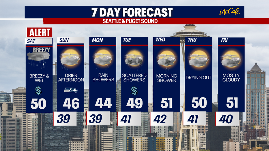
FOX 13 Chief Meteorologist Brian MacMillan has your 7-day forecast
SEATTLE - A strong storm system is moving through Western Washington on Saturday morning bringing gusty wind, lowland rain, mountain snow, and coastal flooding.
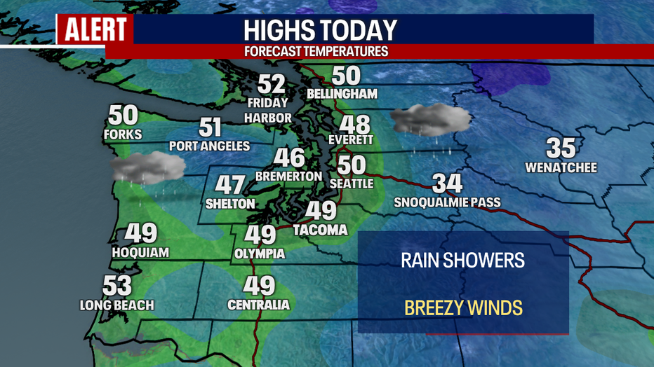
Temperatures are mild on Saturday morning as a southerly wind pushes through the region. Gusty winds will continue through midday, before calming this afternoon and evening. On and off showers will continue through the day.
It will be gusty and wet at times Saturday morning in Western Washington. (FOX 13 Seattle)
WIND
We are seeing some impressive gusts across Western Washington this morning, leaving over 70,000 without power. Here are some of the strongest gusts as of 8:00 AM:
Crystal Mt: 101
Sunrise (Rainier): 85
White Pass: 64
Destruction Is.: 62
Port Townsend: 62
Quillayute: 62
Hoquiam: 62
Smith Is.: 59
Olympia: 56
Bellingham: 55
Whidbey Island: 64
Hurricane Ridge: 49
Everett: 56
Sea-Tac Airport: 38
The strongest winds should taper off by midday, with gusts decreasing in intensity this afternoon and evening.
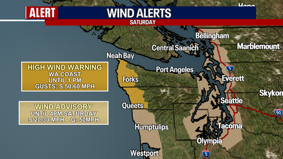
Gusty winds will continue through midday in Western Washington. (FOX 13 Seattle)
MOUNTAIN SNOW
Snow levels will hover around 3,000 to 3,500 feet Saturday, bringing plenty of mountain snow to the higher mountain passes. A Winter Storm Warning is in effect for the Northern Washington Cascades, with 12 to 24 inches possible. Stevens and White Passes could see 5 to 12 inches of snow. Snoqualmie Pass will see less, in the 3 to 6 inch range in the next 24 hours.

Snow levels will remain below the passes through Sunday in the Washington Cascades. (FOX 13 Seattle)
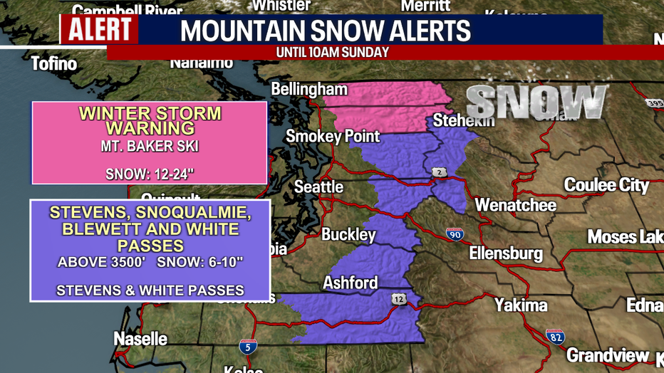
Snow will fall Saturday in the Washington Cascades, with 1-2 feet expected in the northern Washington Cascades. (FOX 13 Seattle)
COASTAL FLOODING
High tide and large waves of up to 20 feet could cause serious flooding along the Washington Coast, where water could surge 2 to 3.5 feet above ground level near the shoreline. Flooding is possible along the Puget Sound shorelines of western Whatcom and western Skagit counties where inundation of up to two feet is possible.
LOOKING AHEAD
Showers will continue through Sunday morning, but Sunday afternoon looks much drier. If you’re heading to the Seahawks game against the Green Bay Packers on Sunday night, it should be dry and cloudy.
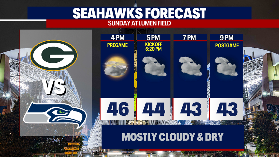
It will be dry, cloudy, and cool for the Seahawks and Packers game at Lumen Field Sunday night. (FOX 13 Seattle)
The next round of widespread rain will hit early Monday morning. Showers continue through Wednesday morning.
After stormy weather Saturday, showers will return early next work week. (FOX 13 Seattle)