

Will it snow in Seattle this weekend? Here's what we know
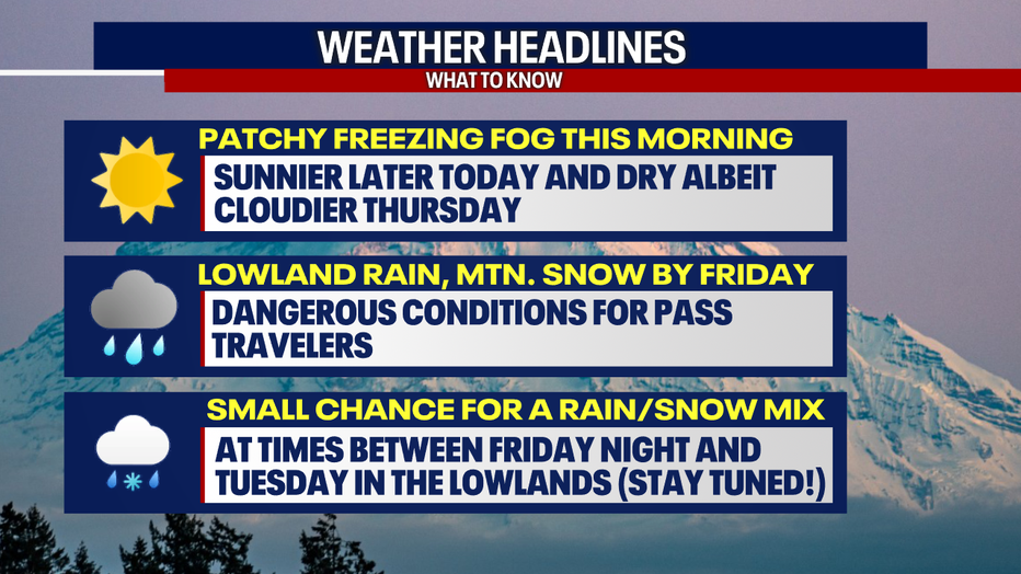
Seattle weather: Chance of freezing fog Wednesday morning
By the weekend, snow levels will continue to fall, bottoming out near 500 feet. This would mean we have a chance at seeing the possibility of some lowland rain/snow mixture.
SEATTLE - Buckle up, Seattleites — there could be a rain-snow mix in the region at times between Friday night and next week.
Check our forecast at least once a day this week because these predictions will change, evolve and become clearer in the coming days.
Local perspective:
This morning, some communities battled freezing fog and chilly temperatures once again. Ice could make driving treacherous, particularly on bridges, overpasses and on-and-off ramps. Untreated sidewalks and parking lots can also be slick in conditions like this, so take it easy today.
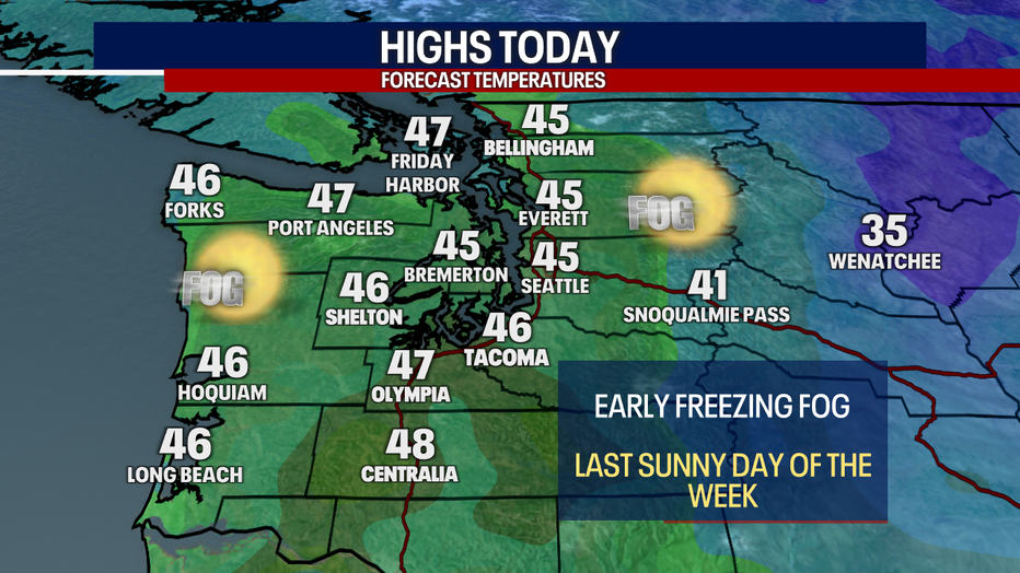
Highs will hover below normal in Seattle on Wednesday afternoon. (FOX 13 Seattle)
Last sunny day in Seattle for a while
Later this afternoon, our plentiful blue skies and sunshine will be an utter delight. This will be our last sunny day for a while, so maximize on the lovely weather today and get outside! Highs will hover in the mid to upper 40s.
There won’t be any big issues over the mountains today, but Blewett and Stevens Passes could have icy spots. Otherwise, there is an Air Stagnation Advisory in effect for much of Central and Eastern Washington due to the quiet weather.
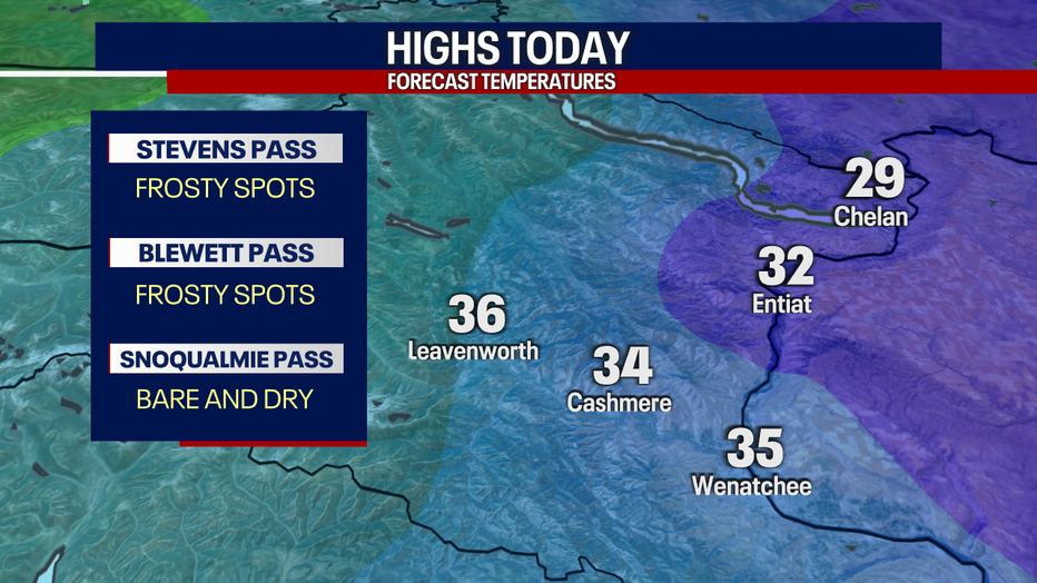
Highs will only reach the mid 30s for most places in Central Washington on Wednesday. (FOX 13 Seattle)
It'll be cloudier on Thursday ahead of our next system arriving by late tomorrow night. Friday and Saturday are looking mostly cloudy, soggy and sloppy with times of steady lowland rain and significant mountain snow.
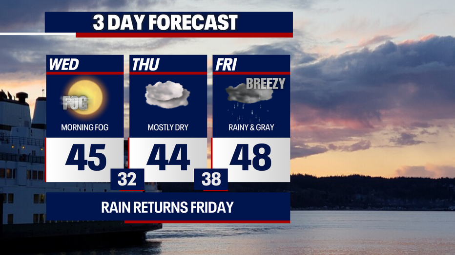
Highs will range in the 40s the next few days with rain returning by late Thursday in Seattle. (FOX 13 Seattle)
Will it snow in the Seattle area this weekend?
What we know:
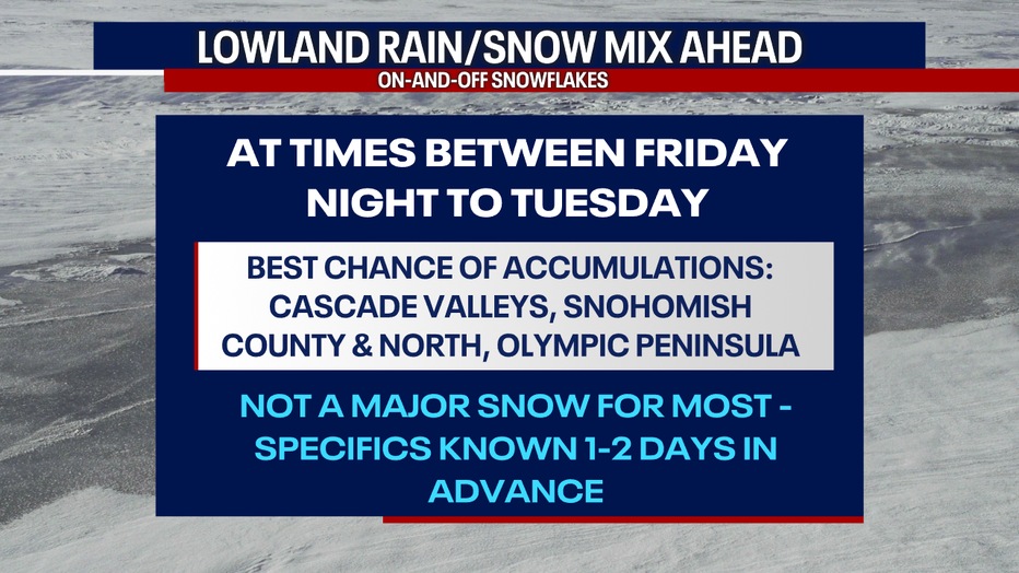
There could be between 14 and 20 inches of snow (or more) accumulating over Stevens, Snoqualmie and White Passes between Friday and Saturday. If you plan on driving over the mountain passes during this two-day stretch, stay tuned to the forecast and check WSDOT conditions before you travel.
If you have the luxury of doing so, we'd recommend adjusting your travel plans so you're not driving in the worst of the snowfall. There will be lesser snow totals on Sunday and even less on Monday.
After freezing fog early Wednesday, we're predicting sunny weather in Seattle this afternoon. (FOX 13 Seattle)
Between Friday night and next Tuesday (and possibly beyond), there may be an occasional rain/snow mix in the lower elevations of Western Washington - especially when temperatures are at their coolest points during the evenings and morning timeframes.
What we don't know:
There's still a lot of uncertainty about how things may pan out. We'll get better clarity on timing, totals and impacts from any lowland snow about 24 to 48 hours ahead of each day.
We'll be bringing you updates multiple times a day.
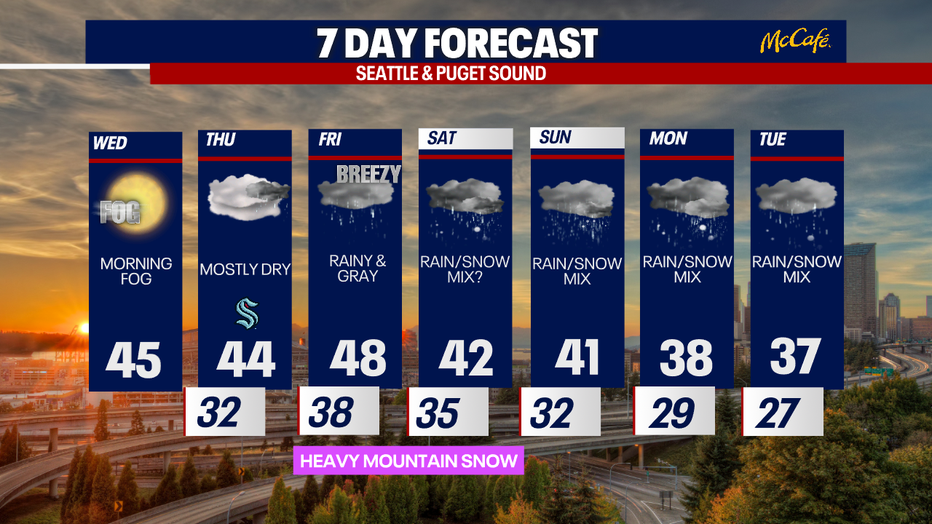
After an extended period of dry weather, a rain/snow mix will develop by Saturday in the Seattle area. (FOX 13 Seattle)
Right now, it seems like there's the best chance of snow accumulation between Friday night and next workweek in the Cascade valleys (take for example, Darrington, Gold Bar, North Bend, Eatonville and Enumclaw), also across Snohomish County up through the Canadian border, and over parts of the Olympic Peninsula (particularly in places like Sequim and Port Angeles, too).
It doesn't seem like this is going to be a major snow event for the highest populated areas like Seattle and Tacoma.
Stick with us as the picture gets clearer in the days to come.
A rain/snow mix is possible in the greater Seattle area at some point this weekend. (FOX 13 Seattle)
Take good care,
Meteorologist Abby Acone and Chief Meteorologist Brian MacMillan
The Source: Information comes from weather models analyzed by FOX 13 Seattle meteorologists Abby Acone and Brian MacMillan.
MORE TOP STORIES FROM FOX 13 SEATTLE
Where migrant ICE raids, arrests are already happening: List
Oldest running movie theater in WA closing, hoping to relocate
Toto, Christopher Cross, Men at Work to rock WA State Fair
What are the chances of a February snow storm in Seattle? Here's what we know
Is it illegal to warm your car up unattended in WA? Here's what you need to know
To get the best local news, weather and sports in Seattle for free, sign up for the daily Fox Seattle Newsletter.
Download the free FOX Seattle FOX LOCAL app for mobile in the Apple App Store or Google Play Store for live Seattle news, top stories, weather updates and more local and national coverage, plus 24/7 streaming coverage from across the nation.