

Seattle weather: Frigid air remains in Western Washington through Tuesday
Seattle weather: Below freezing temperatures continue for Western Washington
FOX 13 Meteorologist Abby Acone has your latest Pacific Northwest weather forecast.
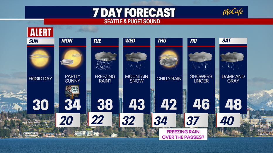
While temperatures are gradually warming after an Arctic front blasted through Western Washington, highs will only reach the 30s the next few days. Dry and sunny weather is in the forecast through Monday, but a rain/snow mix (or even freezing rain) could return to the region Tuesday night.
Highs today will be several degrees above our highs on Saturday. Yesterday, we only reached 22 at Sea-Tac Airport. On Saturday, Bellingham only hit 19 degrees. The low to mid 30s are on tap for highs this afternoon. Enjoy the mix of sunshine and clouds! I'd recommend limiting your time outside, and if you are outdoors - just make to dress in warm layers.

Though no new snow has fallen in the last 48 hours for most of the ski resorts, the snow bases at the ski slopes are increasing thanks to rounds of snow in the high country this week. Tomorrow could be gusty once again in the Cascade gap communities (most likely between the I-90 corridor and the Enumclaw-Buckley area). Gusts could reach between 30-40 mph, but look much weaker than Saturday.
RELATED: Below freezing temperatures continue in Washington; thousands without power
Below freezing temperatures continue in Washington; thousands without power
Thousands remained without power on Sunday as below freezing temperatures linger in Western Washington.
Keep in mind: there are icy spots over the passes. There could also be ice in the Sequim area thanks to recent snow.
RELATED: Puget Sound Energy asking customers to conserve natural gas, electricity during cold snap

For Martin Luther King Jr. Day, mostly sunny skies are on the way. Highs will reach the mid 30s.
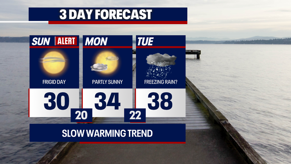
Tuesday looks interesting. As temperatures stay chilly near the surface and an area of low pressure approaches, there could be a rain/snow mix in the lowlands Tuesday night to early Wednesday. We can't even rule out spotty freezing rain in parts of the lowlands in this particular window of time. As warmer air moves in from the south Wednesday morning, temperatures will quickly warm up – melting away any ice accumulations in the lowlands. Stick with us because this type of forecast is very dynamic and sensitive to small things changing (aka the position of the storm or the temperature profile of the air).
Here's a look at the ingredients we need in Western Washington for freezing rain to happen:

Mountain snow will be accumulating throughout the day on Wednesday, potentially making traveling over the passes difficult. Thursday night into Friday afternoon, there's a somewhat small chance for light freezing rain over the passes. Otherwise, we're forecasting snow over the mountains through Friday. Conditions will be changing day-by-day over the higher terrain, so stay tuned for continuous updates!
Hope you stay warm today! Here are links to cold weather shelters:
Take care,
Meteorologist Abby Acone
Follow me on Facebook (Meteorologist Abby Acone), Instagram @abbyaconewx, TikTok @abbyaconetv and X @abbyacone