

Seattle weather: Rainy, breezy storms brewing on Sunday
Seattle weather: Stormy Sunday leads into soggy week
FOX 13 Meteorologist Abby Acone has your 7-day forecast
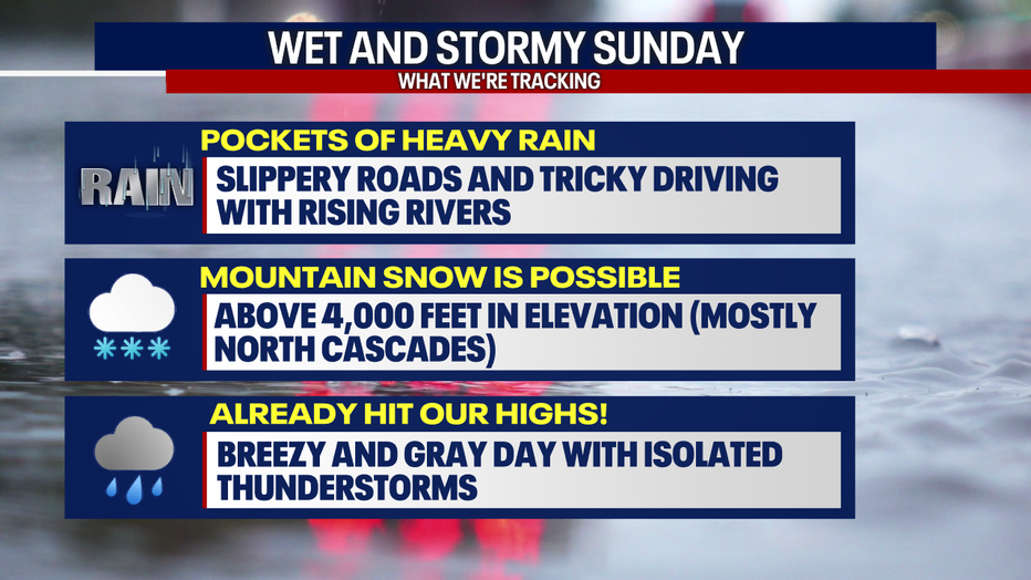
SEATTLE - Pockets of heavy rain, isolated thunderstorms, higher elevation mountain snow and breezy weather are possible across Western Washington on Sunday.
Earlier this morning, Bellingham received more than two inches of rain. Starting just before 5 a.m., a landslide covered the northbound lanes of I-5 in Bellingham just north of Iowa Street.
Rainy and stormy weather is possible in Seattle Sunday afternoon. (FOX 13 Seattle)
Gusty winds also ripped through the region. This morning, gusts peaked at 40 mph in Everett, 48 mph in Hoquiam and 36 mph in Seattle. While it’ll be breezy this afternoon, winds aren’t expected to be as strong. Mostly likely, gusts will fluctuate between 20-30 mph this afternoon.
There will be rounds of heavy downpours, potentially making driving difficult. Water levels will be rising over local rivers, but we’re not predicting river flooding right now. If any storm drains around Western Washington get clogged with leaves and heavy rain develops, there may be hyper-localized street flooding. Remember: never drive into flooded waters!
This afternoon, there could be isolated lightning strikes (especially along the coast), small hail and graupel. There will be a lesser chance for lightning in Seattle during the Hawks game, but the chance isn’t non-zero - so we need to watch conditions closely.
We hit our high temperatures before 7 a.m. today. This afternoon, temperatures will range in the mid 50s.
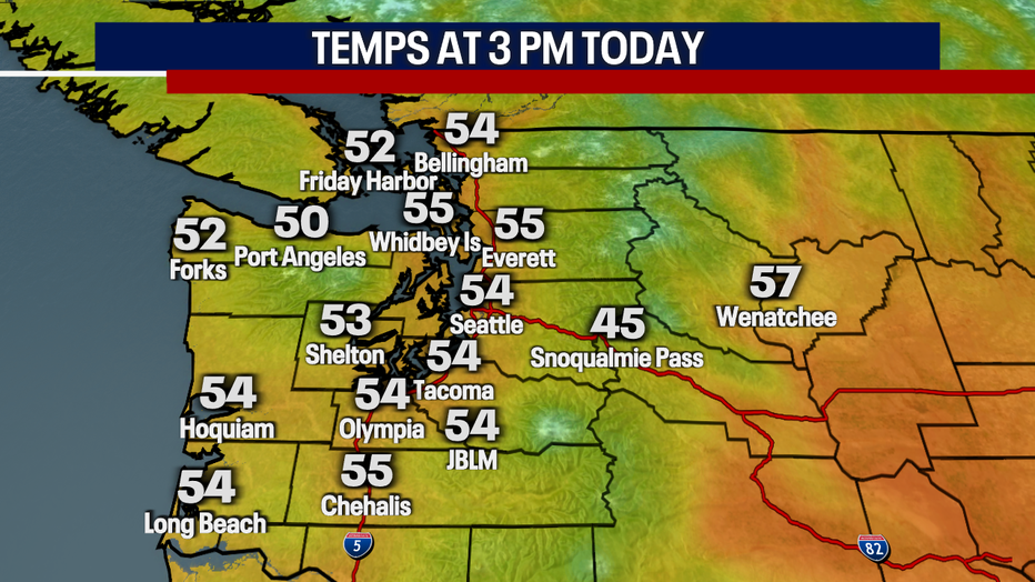
Temperatures on Sunday afternoon will range in the mid 50s for Seattle. (FOX 13 Seattle)
Late tonight to Monday, snow levels could cool down to 4,000 feet in elevation. This could trigger snowflakes falling over White and Stevens Passes, but snow totals seem unlikely in those areas (of course, that could change so stick with us). Right now, we’re forecasting between 5-10 inches of snow accumulating over the North Cascades above 4,000 feet starting tonight.
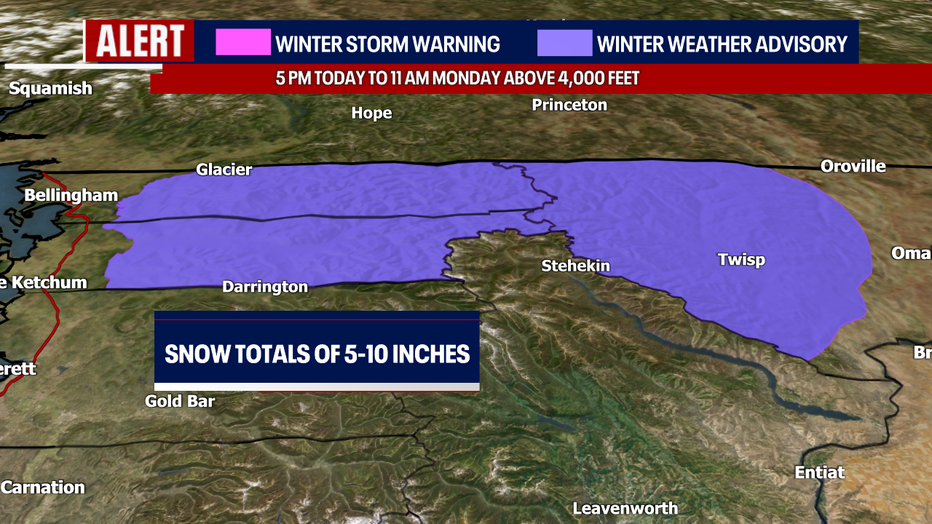
A Winter Weather Advisory is in place for the North Cascades late Sunday to Monday. (FOX 13 Seattle)
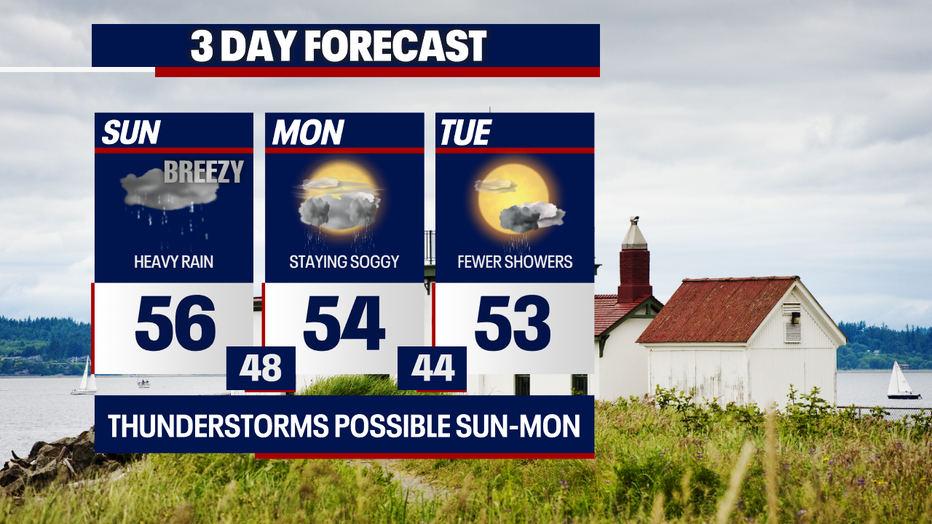
We have another chance for spotty lightning strikes on Monday (primarily over the South Sound and the coast). There could be a few cases of heavy rain as well.
Tuesday looks mostly dry with increasing sunshine.
Spotty lightning and downpours are possible on Sunday and Monday in Seattle. (FOX 13 Seattle)
Hit-or-miss rain lingers for Wednesday, Thursday (Halloween!) and Friday. Saturday could offer less rain. Stay tuned! Here’s a look at your seven day forecast.
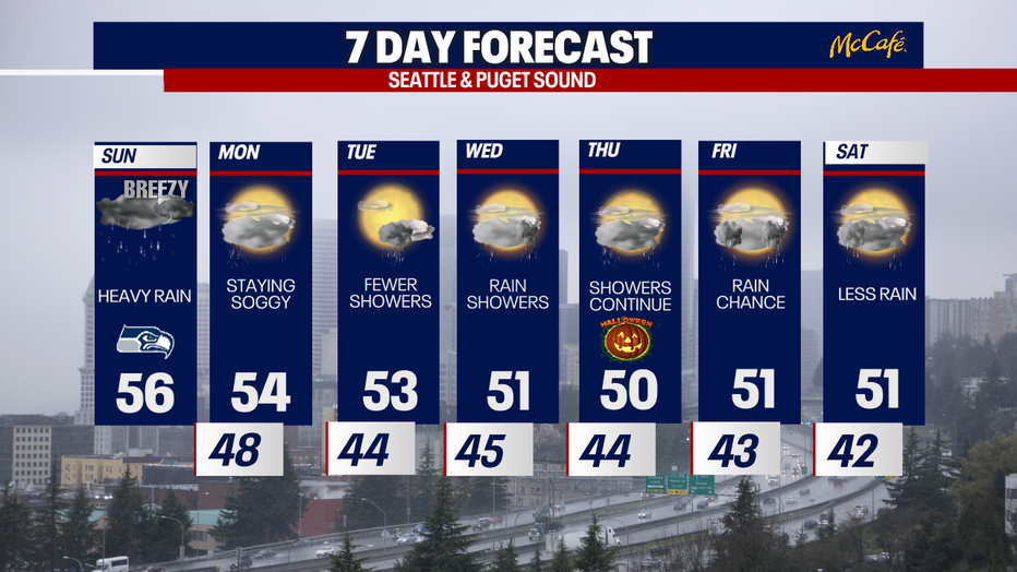
Highs will reach the 50s all week in Seattle. (FOX 13 Seattle)
Take care,
Meteorologist Abby Acone
MORE NEWS FROM FOX SEATTLE
Marysville-Pilchuck High School placed into lockdown after threats
Seattle’s 2025 concert calendar brings top stars to the stage
Seattle Public Schools moves ahead with 4-school closure plan, merger
Docs: Fall City teen gunned down family, staged ‘murder-suicide’
Viral TikTok sends Snohomish, WA coffee stand into a frenzy
Former WA prosecutor indicted in King County Jail drug smuggling ring
To get the best local news, weather and sports in Seattle for free, sign up for the daily Fox Seattle Newsletter.
Download the free FOX Seattle FOX LOCAL app for mobile in the Apple App Store or Google Play Store for live Seattle news, top stories, weather updates and more local and national coverage, plus 24/7 streaming coverage from across the nation.