

Seattle weather: Lowland rain and mountain snow
Seattle weather: lowland rain and mountain snow
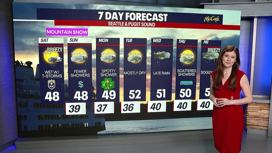
FOX 13 Meteorologist Abby Acone has your seven-day forecast.
SEATTLE - New weather systems are beginning to roll into western Washington this weekend. A couple of key developments worth discussing are winter storm warnings, mountain pass travel, and when to expect dry weather to return, so let's dive right in.
Winter Storm Warning Alert
A winter storm warning is affecting the mountain passes, which is in effect until 11 a.m. tomorrow for elevations above 2000 feet. During this period, travel could become difficult, if not impossible, at times. Conditions are expected to worsen throughout the day, with Saturday night being particularly challenging.
We're anticipating rounds of moderate to heavy snow, so if you have the option to delay your travel plans until tomorrow afternoon, our meteorologist, Abby Acone, highly recommends doing so.
Even if you're a seasoned driver, remember that others on the road might not be as experienced. Not everyone adheres to washout restrictions, so it's something to keep in mind as you plan your journey.
Mountain Passes and Washout Restrictions
Navigating the mountain passes can be tricky, so make sure to check those washout restrictions. Meanwhile, Lapush is currently enjoying a few hints of sunshine. While you might catch some sunshine today, be prepared for blustery weather.
Thunderstorms, small hail, graupel, and pockets of heavy rain are sweeping through southwest Washington. Areas like Hoquiam, Montesano, Skagit, and Whatcom counties are in for a big drink of water.
Snohomish County is experiencing windy conditions, with gusts forecasted to reach around 40 mph. However, it's unlikely to be widespread or long-lasting enough to warrant a wind advisory.
Futurecast: What to Expect
Looking ahead, our second area of low pressure will bring more extensive lowland rain and mountain snow this evening. Hour by hour, expect damp weather at noon, showers continuing into the afternoon, and evening rain by ten.
It's not going to be a constant downpour, and you might see hints of sunshine here and there. Be prepared for alternating downpours. Temperatures will vary, with some areas like Bellevue and Issaquah reaching the low 50s, while others like Lakewood, Gig Harbor, and Belfair North will feel cooler in the upper 40s. Out west, Long Beach might hit 50, but Aberdeen will likely fall short.
Seven-Day Forecast: A Glimpse Ahead
Tomorrow promises fewer showers, which will be a welcome change. Saint Patrick's Day will feature spotty showers and glimpses of sunshine.
Tuesday looks mainly dry, with dry conditions during the daytime on Wednesday before rain returns in the evening. Scattered showers will accompany the arrival of spring on Thursday, marking the spring equinox. Let's embrace the change!
Friday brings an atmospheric river, with lowland rain, mountain snow, and some wind. Overnight temperatures will dip into the mid-30s, so keep that in mind. As always, the weather can be unpredictable, and this forecast is subject to change.
Stick with us for the latest updates as we break down the evolving conditions. Stay safe and weather-aware!
The Source: Information for this article comes from original FOX 13 reporting.
MORE TOP STORIES FROM FOX 13 SEATTLE
Thieves steal 60 guns from South Hill, WA storage units
FBI urges public to delete WA Good to Go text scam messages
Best time to see the UW cherry blossoms in Seattle
Seattle Seahawks reach deal with WR Cooper Kupp
Flushing illegal contraband behind bars; WA youth facility leader says it’s 'OK'
To get the best local news, weather and sports in Seattle for free, sign up for the daily FOX Seattle Newsletter.
Download the free FOX LOCAL app for mobile in the Apple App Store or Google Play Store for live Seattle news, top stories, weather updates and more local and national coverage, plus 24/7 streaming coverage from across the nation.