

High wind warning issued for Seattle area Monday night
Rain, wind to hit western WA
FOX 13 Seattle Meteorologist Abby Acone says to expect gusty winds and rain on Monday and Tuesday.
SEATTLE - Forceful winds could develop in the Seattle area Monday night to Tuesday morning. While this won’t be a major storm for most, some communities will be facing power outages and tree damage by Tuesday morning.
The impacts and wind speeds all hinge on the timing and track of the incoming storm.
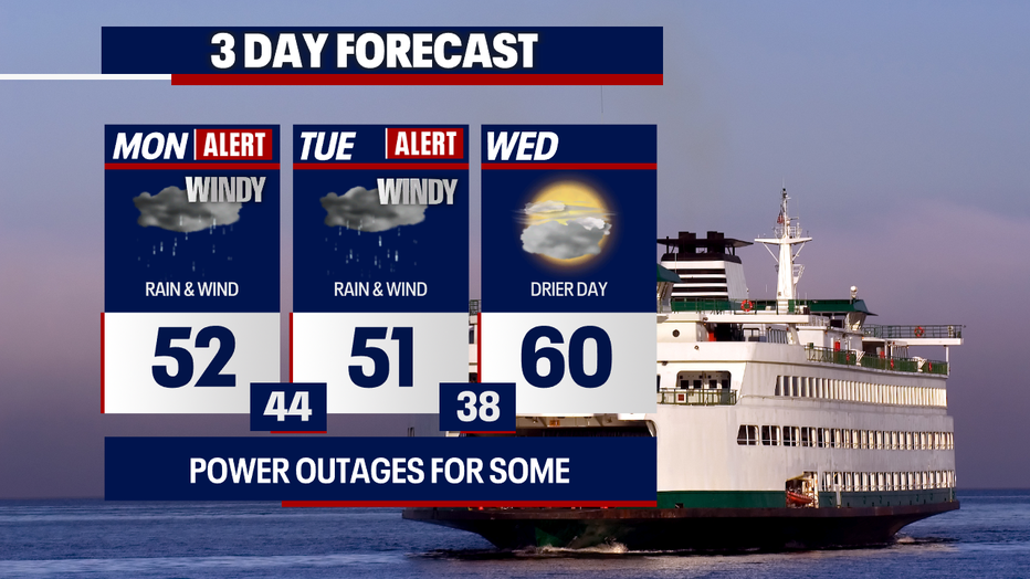
Temperatures will rebound to the upper 50s to low 60s on Wednesday in Seattle. (FOX 13 Seattle)
Timeline:
Monday daytime
- Rounds of rain will increase around western Washington this afternoon and tonight.
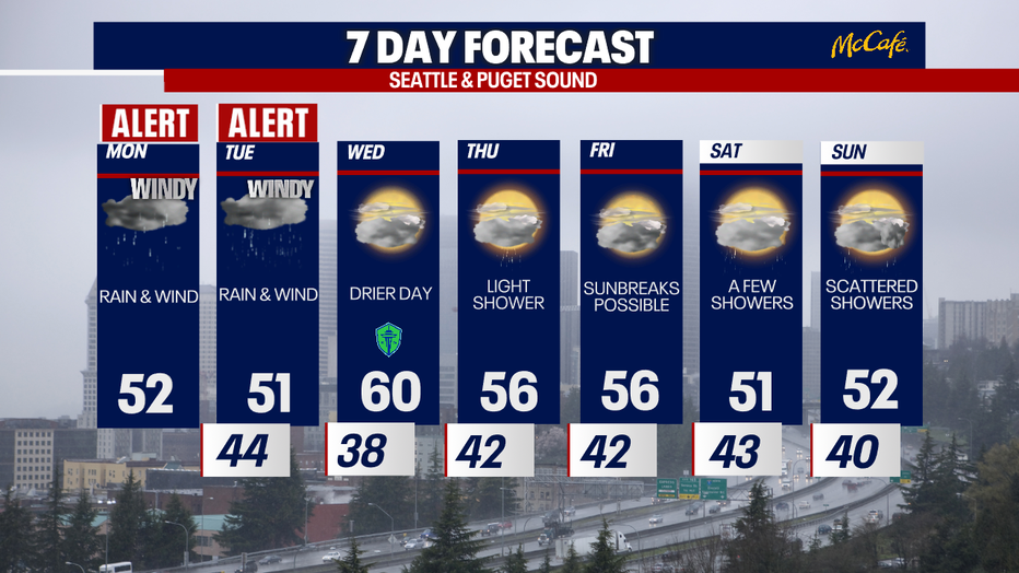
- People can expect cloudy skies during the day with highs in the low 50s for most in Puget Sound.
- By around 4 p.m., the winds will pick up around the region.
- The evening commute could be gusty and rainy.
- Rain will fall over the passes before transitioning to snow for Stevens and White passes by about 7 p.m. Snoqualmie Pass could see snow as early as 7, but there’s a better chance of rain switching to snow later tonight.
Monday night to early Tuesday
- Winds become rather widespread by 7 p.m., but gusts won’t peak for many in Puget Sound until between 10 p.m. today and 4 a.m. Tuesday. Winds will ease much more substantially by noon on Tuesday.
- Some communities could wake up to power outages and downed trees. Greater impacts are expected in the South Sound and along the coast.
- Should winds get as strong as we expect, there could be roads closed due to downed trees in addition to dark intersections with the power off.
- Pockets of moderate-to-heavy rain could slow the early commute, too.
- Traveling will become quite challenging over the mountains – particularly at Stevens and White passes. There’s a small chance that snow will be accumulating at Snoqualmie Pass, too.
- There’s an elevated risk of landslides around Western Washington and avalanches in the backcountry of the mountains.
Tuesday afternoon
- Showers will gradually taper Tuesday afternoon – except for where a convergence zone is ongoing.
- Winds will relax throughout the afternoon and evening.
Wind alerts
- Gusts could reach upwards of 55-65 mph along the Washington coast. That’s where high surf could create super dangerous conditions along the water as well.
- Gusts could range between 50-60 mph for the South Sound, Kitsap Peninsula and the Southwest Interior.
- For those covered in a wind advisory, there could be gusts to 45-50 mph.

Strong winds will increase Monday evening to Tuesday morning in the greater Seattle area. (FOX 13 Seattle)
Flood alerts:
- There’s a flood warning for the Skokomish River.
- There’s also a flood watch for southwest Washington due to rivers, creeks and streams rising.
- A coastal flood advisory is posted for the south Washington coast for the potential of minor tidal overflow.
- A high surf advisory is posted for the Central and north Washington coast for large, breaking waves to 15 to 25 feet.
- A high surf warning is in effect for the south Washington coast for breakers up to 35 feet. Waves will be dangerous and severe beach erosion is possible.
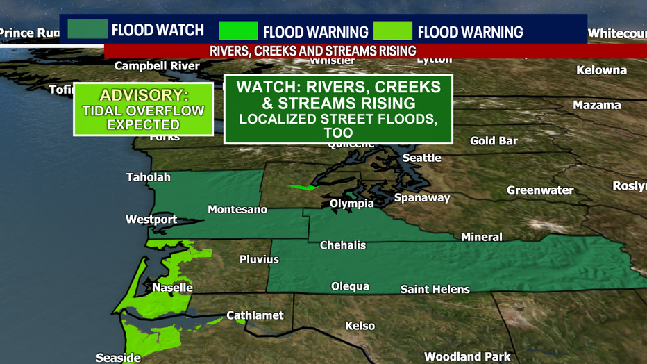
There are several flood alerts in effect around Southwest Washington. (FOX 13 Seattle)
Mountain alerts:
- A winter storm warning is posted for most of the Cascades above 4,000 feet in elevation. Upwards of one to two feet of snow could fall, depending on the location.
- Between 5-12" of snow (or more) could fall along Snoqualmie Pass: totals there will depend on how quickly temperatures cool to the freezing mark tonight (if they cool that low at all).
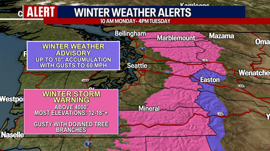
Several winter weather alerts will be in effect for the Washington Cascades Monday into Tuesday. (FOX 13 Seattle)
Drier, quieter and milder weather returns on Wednesday. Some backyards could experience their first 60-degree day of the year!
Rainy and windy weather will continue in Seattle through Tuesday morning. (FOX 13 Seattle)
The Source: Information in this story comes from FOX 13 Seattle Meteorologist Abby Acone and Chief Meteorologist Brian MacMillan.
MORE TOP STORIES FROM FOX 13 SEATTLE
WSP investigates deadly I-5 crash in Marysville, WA, possibly road rage
Puyallup man killed, family now sending ashes back to Japan: ‘That’s his final trip’
4 arrested following car jacking, crash, chase in Spanaway, WA
‘You steal for a living’: Everett antique store confronts accused serial shoplifters
Pirate plunders boat motors from Gig Harbor, WA marina
To get the best local news, weather and sports in Seattle for free, sign up for the daily FOX Seattle Newsletter.
Download the free FOX LOCAL app for mobile in the Apple App Store or Google Play Store for live Seattle news, top stories, weather updates and more local and national coverage, plus 24/7 streaming coverage from across the nation.