

Drenching rain and gusty weather return to Seattle
SEATTLE - An atmospheric river is taking aim at western Washington, blasting drenching rain to parts of the region today through Monday.
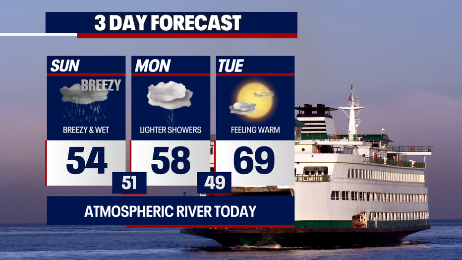
Highs this afternoon will reach the mid 50s for most backyards in the region. You can expect dark, cloudy skies and times of soaking rain.
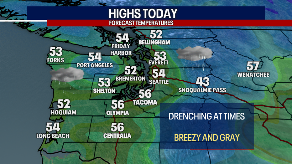
Temperatures will hover around average, reaching the mid 50s in Seattle on Sunday afternoon. (FOX 13 Seattle)
The North Coast, Northwest Interior, Olympics and Central and North Cascades will experience the heaviest rain today through Monday.
It'll be blustery today. In some isolated cases, gusts could reach upwards of 40 mph; however, this will likely be the exception rather than the rule. For the most part, winds won’t be strong enough to warrant any official alerts like Wind Advisories.
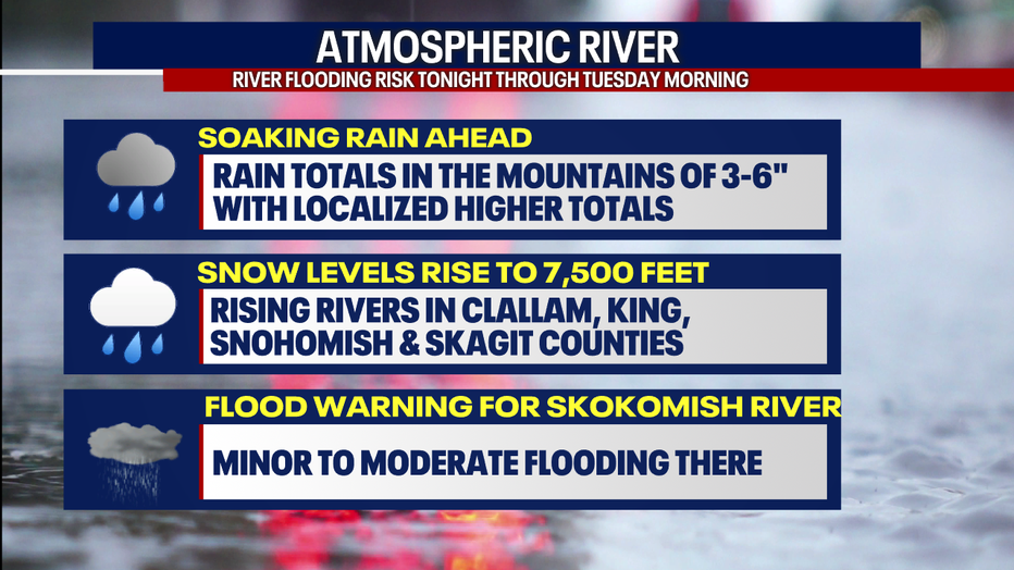
Due to the incoming rain combined with melting snow over the mountains, local rivers will be rising. There’s a Flood Watch for Clallam County because the Bogachiel River could reach minor river flooding by Monday.
A Flood Warning is posted for the Skokomish River in Mason County. There, moderate flooding is expected. Rivers in Skagit, Snohomish and King Counties will also rise. Some of these waterways could approach minor flood stage. Just how much the water increases depends on where the strongest bands of rain develop.
Heavy rain could contribute to rising river levels around Western Washington on Sunday. (FOX 13 Seattle)
Earlier this morning, snow blanketed Mount Baker and Stevens Pass. Snow levels will be elevating to 7,500 feet later today. Due to these rapidly-changing conditions, an Avalanche Warning is posted for the Cascades. Avoid doing any skiing or snowboarding in the backcountry of the mountains. Under these conditions, avalanches could bury, injure or kill someone.
On Monday, the atmospheric river will continue spreading rain through places like the North Coast, the San Juans, Bellingham and the North Cascades. Elsewhere, only isolated showers are forecast tomorrow. River levels will stay elevated.
Temperatures will rebound to the upper 60s on Tuesday in Seattle. (FOX 13 Seattle)
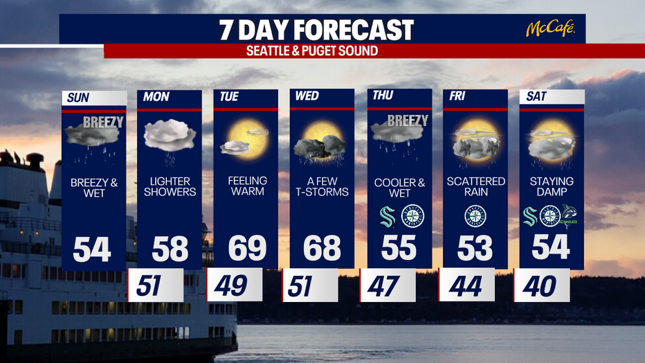
On Tuesday, the weather dries out altogether. The morning may be cloudy and murky, but the afternoon should be partly sunny with highs almost reaching 70 in Seattle! Some of the outlying communities could easily see their first 70 degree day of the year.
As an area of low pressure approaches Western Washington on Wednesday, there might be enough instability in the atmosphere to trigger scattered thunderstorms. Storms could be slightly stronger than usual. Stay tuned as we monitor this part of the forecast carefully!
For the Mariners home opener, it might be cloudy, wet and breezy. We’ll track it closely.
Showers and cooler weather linger into Friday and Saturday. Snow levels will drop to the elevation of Stevens and Snoqualmie Passes.
Buckle up for a roller coaster of weather in Seattle this week: we'll go from soaking rain on Sunday to highs almost reaching 70 on Tuesday! (FOX 13 Seattle)
That’s a look at your forecast! Stick with the FOX 13 weather team as we keep a close watch on this dynamic, evolving outlook.
Warmly,
Meteorologist Abby Acone
The Source: Information for this article comes from the FOX 13 weather team.
MORE TOP STORIES FROM FOX 13 SEATTLE
Top aide for WA Gov. Ferguson resigns over workplace complaints, report
Seattle police arrest man accused of more than 20 bank robberies
Here's where Seattle renters are relocating
Seattle's Capitol Hill Block Party announces 2025 lineup, changes to event
Could Bryan Kohberger’s autism defense for capital murder set a precedent?
To get the best local news, weather and sports in Seattle for free, sign up for the daily FOX Seattle Newsletter.
Download the free FOX LOCAL app for mobile in the Apple App Store or Google Play Store for live Seattle news, top stories, weather updates and more local and national coverage, plus 24/7 streaming coverage from across the nation.