

Why tree coverage matters as temperatures rise in Puget Sound
Why tree coverage matters during the hot summer months
As unseasonably hot temperatures roll into Puget Sound this weekend, scientists will be on the ground in Tacoma as part of a months-long research project tracking how trees impact communities.
TACOMA, Wash. - As unseasonably hot temperatures roll into Puget Sound this weekend, scientists will be on the ground in Tacoma as part of a months-long research project, tracking how trees impact communities.
Trees are essential to communities the remove street-level air pollution, and reduce heat island effects. According to City of Tacoma data, neighborhoods can fluctuate by 10 to 15 degrees during extreme heat events.
Tacoma also has the least amount of tree canopy of any community in Puget Sound.
While as a whole, Tacoma’s tree canopy covers 20%, there are communities—like the Tacoma Mall neighborhood—that have just half of that.
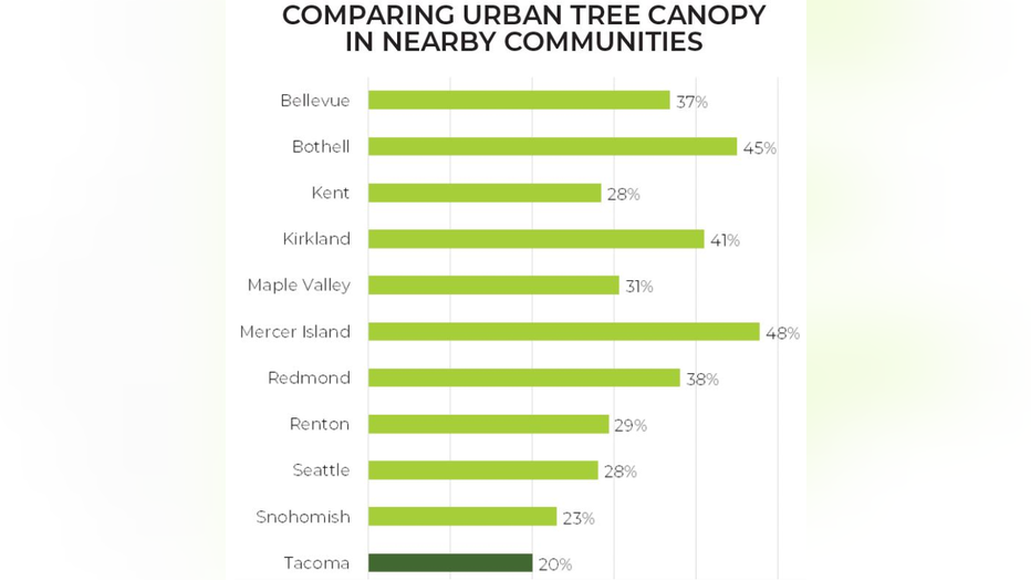
A breakdown of urban tree canopy in Tacoma and nearby communities from the City of Tacoma in 2018.
"We know certain neighborhoods are hotter than others," explained Lowell Wyse, the executive director of Tacoma Tree Foundation. "We know that’s connected to what the physical environment looks like: lots of pavement, not as much tree coverage."
Wyse’s group works on a neighborhood level to plant trees where people want them, and where they’ll have the most impact.
Tacoma Tree Foundation recently planted 62 trees at Madison School, a location that was essentially a vacant lot when it came to tree canopy.
Wyse points to research that has found that more tree cover around schools leads to better standardized test scores.
"In general, we know trees are correlated with cooler temperatures, and in that sense, more safety in the summer with heat events," he said. "We don’t know on a block level, does one tree matter or is it really the presence of larger stands of trees."
The Greening Research in Tacoma (GRIT) project is trying to find answers to that question. The City of Tacoma, The Nature Conservancy, Tacoma Tree Foundation and University of Washington are in the middle of a project that monitors temperatures before, during and after green infrastructure installation.
Air temperatures sensors have been place around the Tacoma Mall neighborhood in South Tacoma. Those sensors regularly collect data, and on especially hot days, they launch volunteers to measure surface temperatures, as well. An upcoming event will offer the opportunity for locals to learn more about the research, and take part in the project this Saturday.
"Trees can offer a solution we can all participate in the face of climate change, in particular, as our cities are warming and a global level," said Dr. Ailene Ettinger, a qualitative ecologist with The Nature Conservancy. "It’s important that communities at local scales have tools that will help them be more resilient."
Dr. Ettinger points out that community-led science projects like this can help us better understand not just data, but the human experience of this work too.
Part of the GRIT project involves personal interviews with members of the Environment & Well-Being Lab at University of Washington.
Those personal connections are important, because a lack of tree canopy cover can create inequities in communities that are hard to overcome.
During extreme heat events, the swing in temperatures between communities with tree cover can be a life or death difference. The 2021 Pacific Northwest heat dome was an event that saw people die in the Tacoma Mall neighborhood.
"There is a complicated history of disinvestment in lots of neighborhoods often tied to systemic racist practices," said Dr. Ettinger. "So, it’s a current problem, but it’s grounded in historic practices."
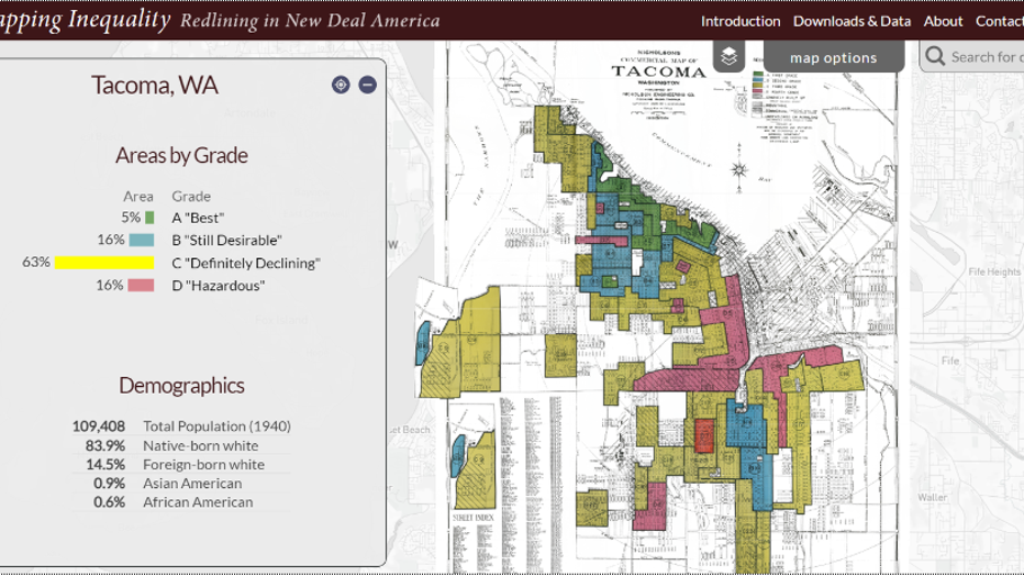
The "Mapping Inequality - Redlining in New Deal America" project from Robert K. Nelson, LaDale Winling, Richard Marciano, Nathan Connolly, et al. located this map created by the government's Home Owners' Loan Corporation -- it shows how areas were re
Those practices include redlining, a series of race-based exclusions that changed cities and counties across the U.S. Those policies ranged from steering Black home buyers to certain neighborhoods, to racial covenants that barred Black residents from buying homes.
You can get a closer look at how neighborhoods were assigned grades based on the race of residents. Maps set up by federal agents can be found through the "Mapping Inequality: Redlining in New Deal America" project. Many of those redlined neighborhoods now correlate with communities that have the least tree canopy.
While the history of how areas found themselves with a disproportionate tree canopy can be difficult, it doesn't mean communities are doomed. If there is any positive to be found in the current research, it's that adding trees to a community can have a positive effect.
RELATED: Officials urge water safety this weekend as warmer weather comes in
Get breaking news alerts in the FREE FOX 13 Seattle app. Download for Apple iOS or Android. And sign up for BREAKING NEWS emails delivered straight to your inbox.
If you’d like to take part in the upcoming temperature monitoring event with The Nature Conservancy and Tacoma Tree Foundation you can find more information on their website.